In addition to being accessible from the top navigation bar, NOAA Coral Reef Watch's (CRW) decision support products for coral reef ecosystem management can be accessed from the tables and links below.
Note: If you are looking for a particular CRW product but cannot locate it below, or if you have an inquiry about any of our products or services, please contact us at coralreefwatch@noaa.gov.
Table of Contents
(version 3.1 [v3.1], 1985-present, released August 1, 2018)
|
CoralTemp (introduction) Sea Surface Temperature (SST) |
Current Con- ditions |
Images (Global, Regional) |
Anim- ations |
Google Map |
Google Earth |
NetCDF Data |
Pixel Images |
(v3.1, 1985-present, released August 1, 2018)
|
Near Real-Time and Archived Products (home page) |
Current Con- ditions |
Images (Global, Regional) |
Anim- ations |
Google Map |
Google Earth |
NetCDF Data |
Pixel Images |
|
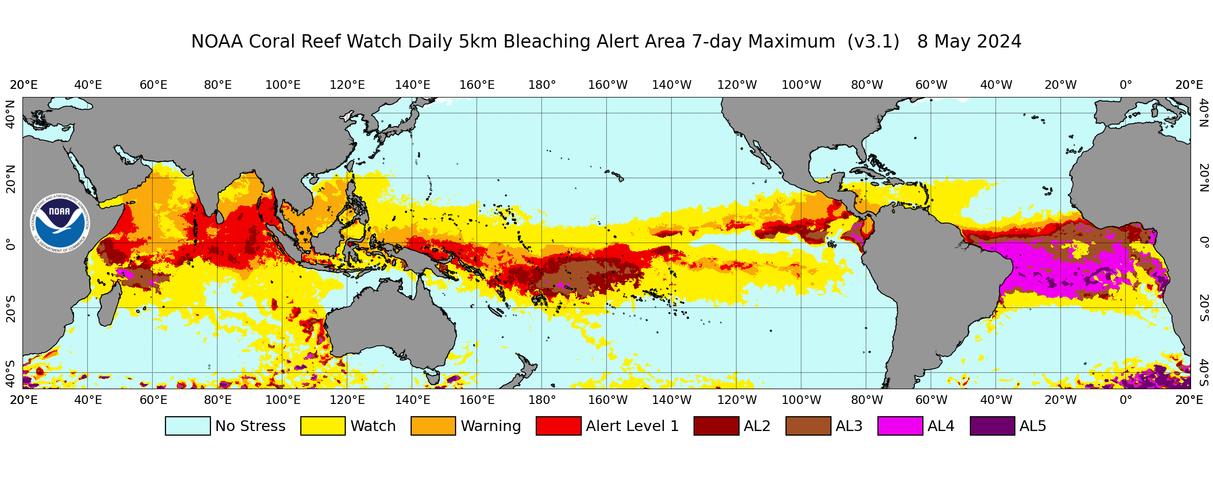
Bleaching Alert Area (7-day max) Bleaching alert status (maximum alert over 7 days) |
X | X | X | X | X | X | X |
|
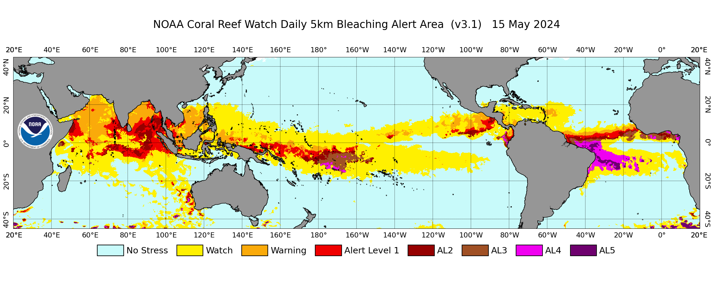
Bleaching Alert Area (single-day) Bleaching alert status (single day alert) |
X | X | -- | -- | -- | X | X |
|
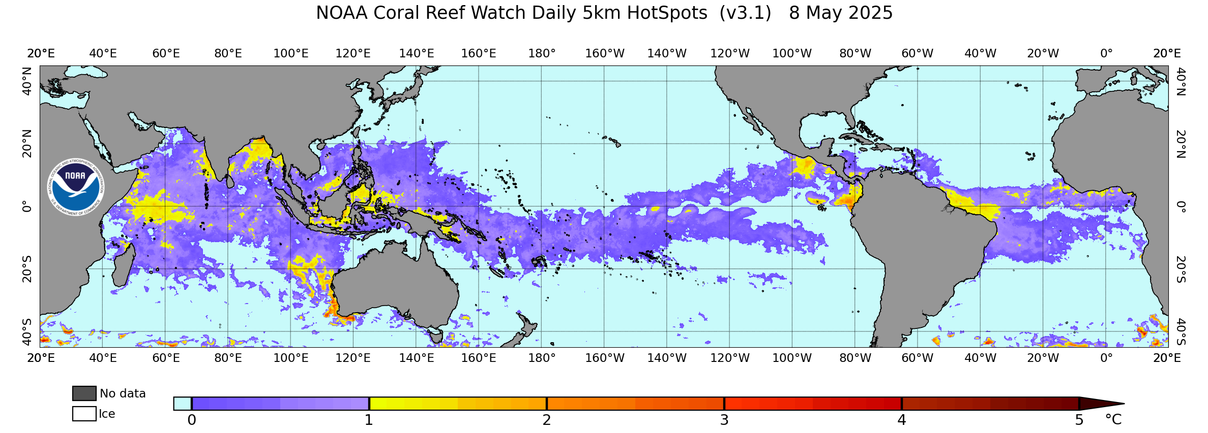
Coral Bleaching HotSpot Current heat stress (HotSpot) |
X | X | X | X | X | X | X |
|
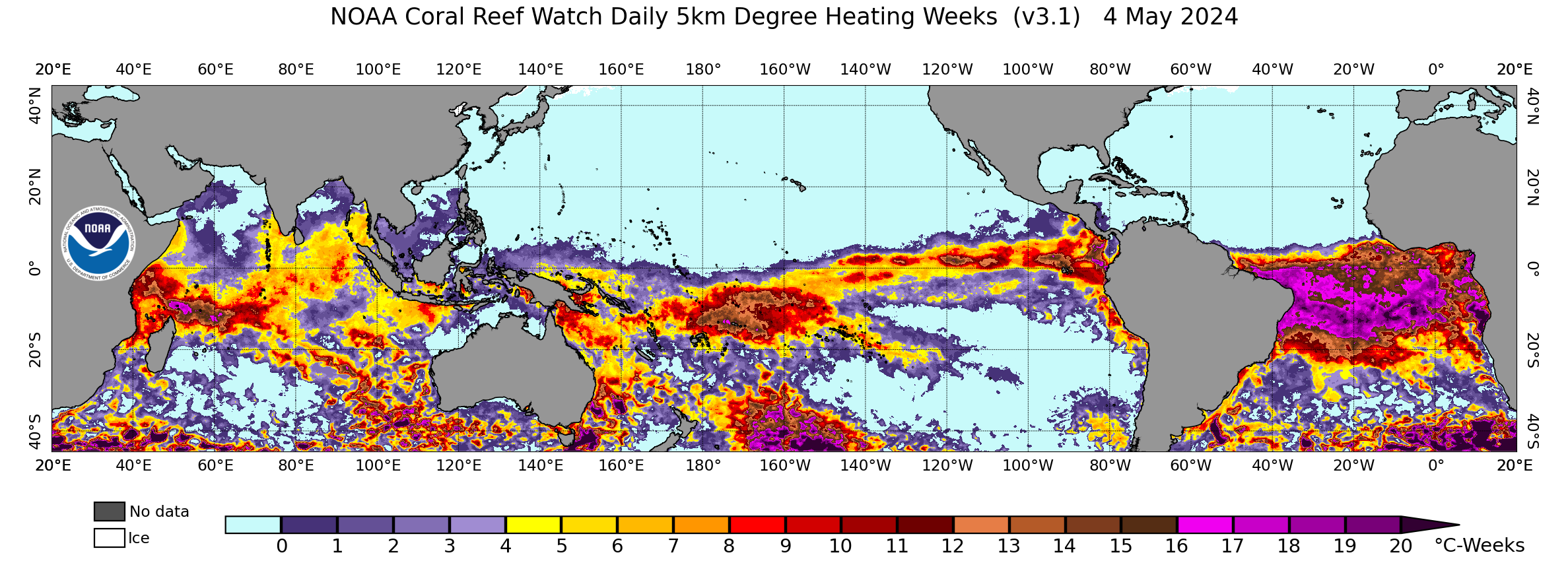
Degree Heating Week Accumulated heat stress (DHW) |
X | X | X | X | X | X | X |
|
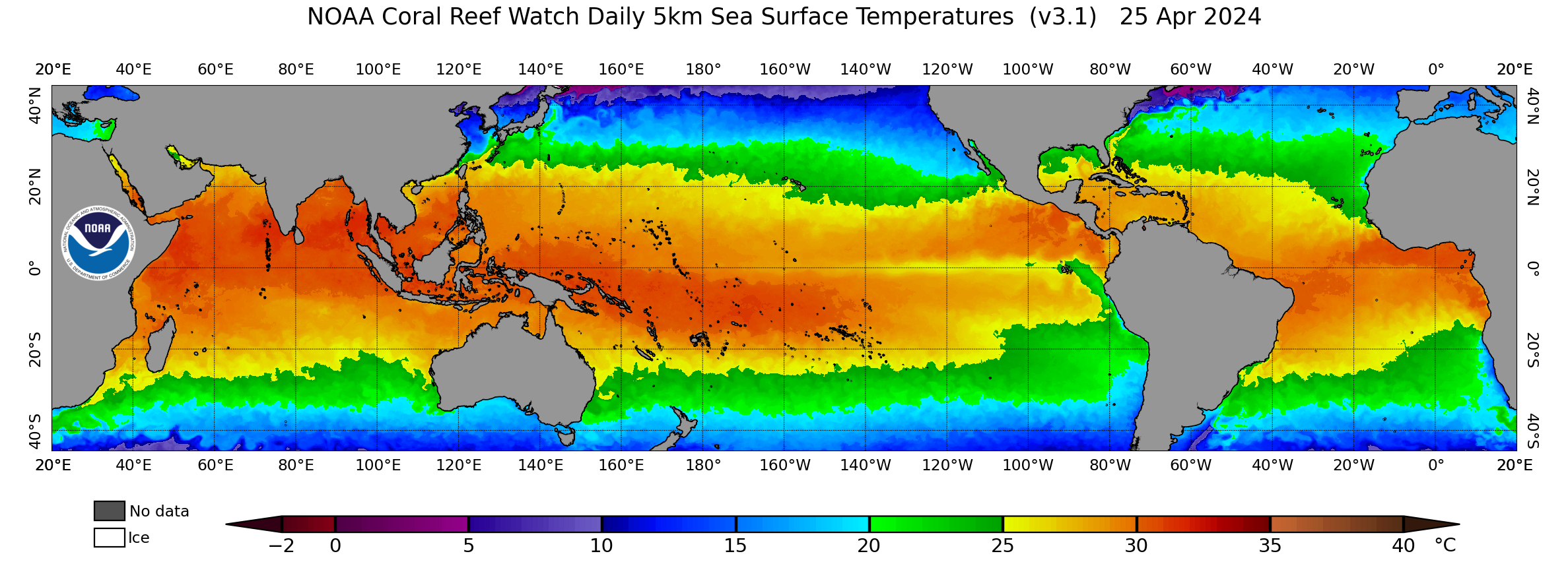
SST (CoralTemp) Sea Surface Temperature |
X | X | X | X | X | X | X |
|
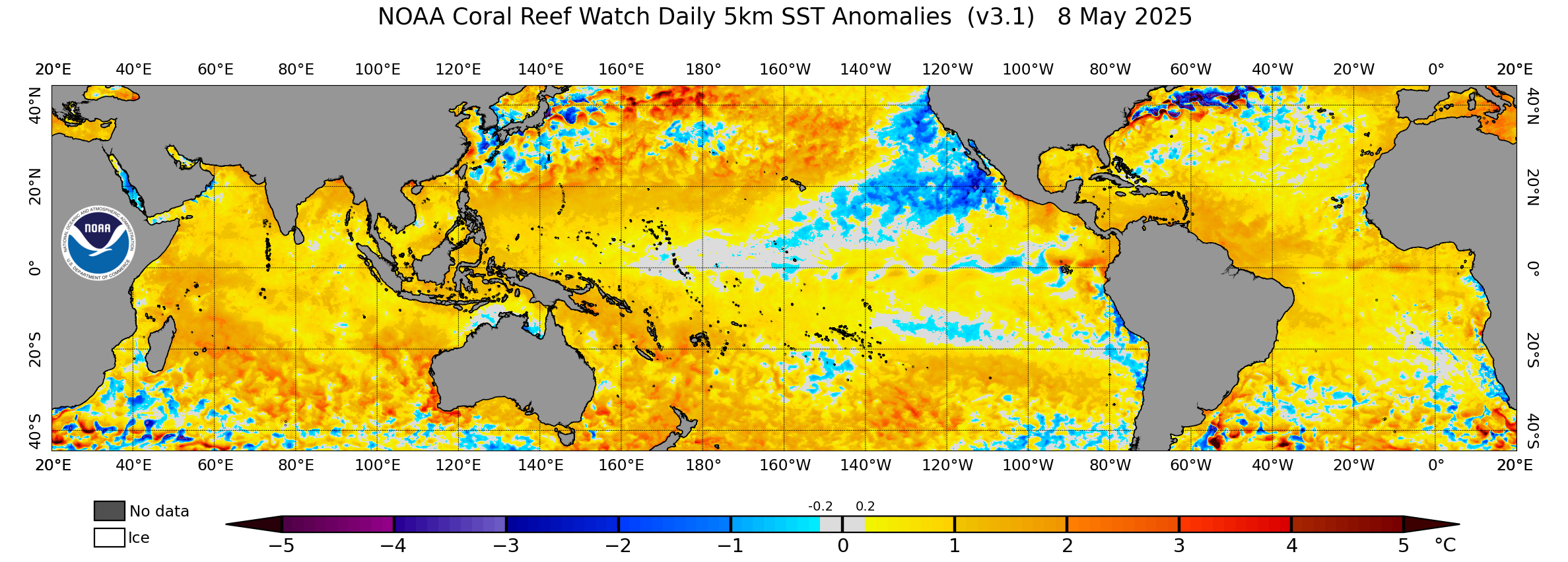
SST Anomaly Sea Surface Temperature anomalies |
X | X | X | X | X | X | X |
|
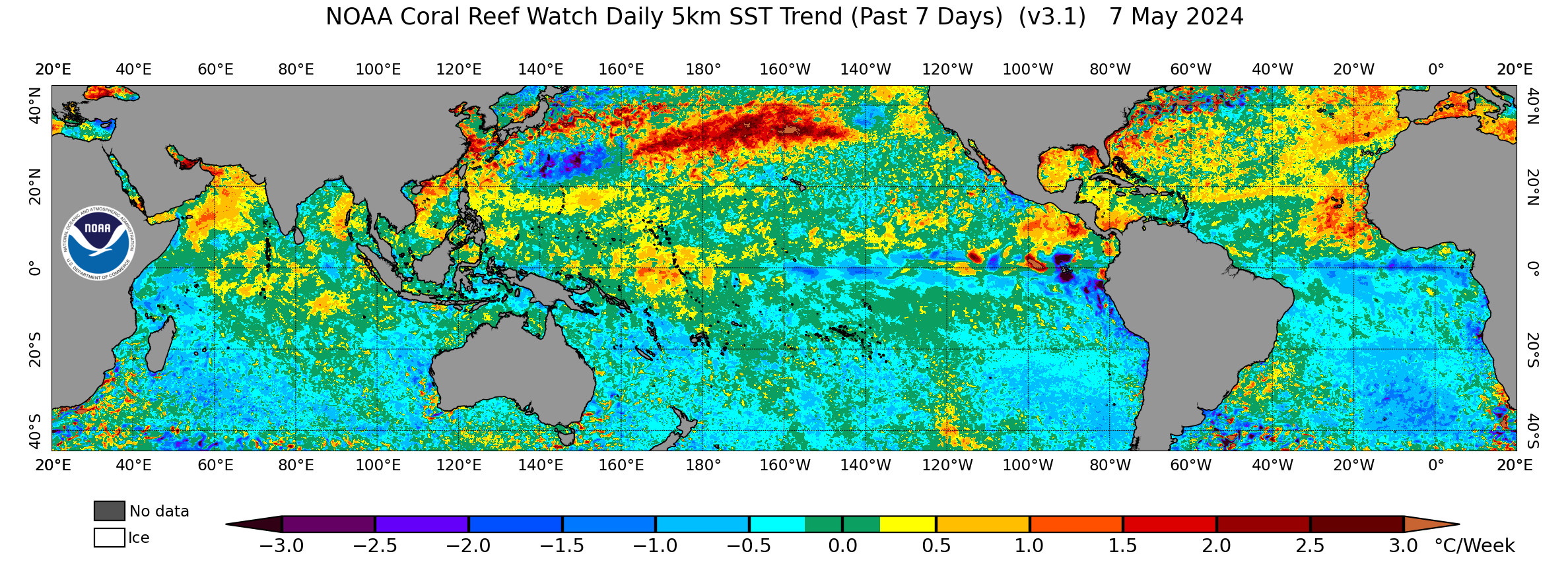
7-Day SST Trend Sea Surface Temperature trend for the last 7 days |
X | X | X | X | X | X | X |
|
Composites (home page) Year-to-date, monthly, and annual composites of the v3.1 daily global 5km satellite products |
X | X | -- | -- | -- | X | X |
|
Climatologies Monthly and Maximum Monthly Mean (MMM) climatologies of the daily global 5km products |
-- | -- | -- | -- | -- | X | X |
(v3.1, 1985-present, released July 31, 2019)
|
Regional Virtual Stations (5km) (home page) 219 satellite-based regional coral reef sites (with 5 duplicated Stations in overlapping regions) |
Current Stress Levels |
Stations List |
Google Map |
Google Earth |
Gauges |
Maps & Images |
Time Series Graphs |
Time Series Data |
|
Satellite Bleaching Alert Email System
(home page) Automated for 219 Regional Virtual Stations, 5 of which are duplicated in overlapping regions |
Current Stress Levels |
Stations List |
Stations on Map |
Intro |
Sample |
Sub- scribe |
Unsub- scribe |
Contact Us |
(1985-present, multiple U.S. states and territories)
(v5, 2011-present, released March 27, 2018)
|
Four-Month Coral Bleaching Outlook (home page) Four-month composites & individual weekly outlooks |
Latest Outlook |
Images (Global, Regional) |
Anim- ations |
Google Map |
NetCDF Data |
Pixel Images |
Archive |
| Current Con- ditions |
Image Archive |
Anim- ations |
Google Earth |
NetCDF Data Archive |
Time Series Data |
E-mail Alerts |
|
|
Marine Heatwave Watch (v1.0.1) (home) -- 1985-present; released September 21, 2021 Daily global and regional 5km maps identifying areas of prolonged, anomalously high SST |
X | X | -- | -- | X | -- | -- |
|
Coral Disease Outbreak Risk (v2) (home) -- 1985-present; released June 11, 2019 Disease outbreak risk maps (Hawaii and Australia's Great Barrier Reef) |
X | X | -- | -- | -- | -- | -- |
|
Multi-Factor Coral Disease Risk (home) -- May 4, 2021-present; released May 4, 2021 Coral disease nowcast and forecast maps and graphs predicting growth anomalies and white syndromes risk (US Pacific Islands and Great Barrier Reef) |
X | -- | -- | -- | -- | -- | -- |
|
Ocean Color (v1.0) (home) -- 2012-present; released May 2018 Chlorophyll-a and Kd(490) monitoring at 750m from VIIRS satellite (Hawaii and Puerto Rico) |
X | X | -- | -- | X | X | -- |
|
Thermal History (v3.5) (home page) 1985-2023; released January 31, 2024; updated annually |
Images | NetCDF Data |
|
|
Click here for a complete list of product metrics. |
X | X |
| Real-time Update |
Scheduled Update |
Images | NetCDF Data |
|
|
Larval Connectivity (home page) Potential connectivity of larvae among reefs/atolls (Hawaii/Johnston Atoll and Florida) |
No | No | X | X |
| Real-time Update |
Scheduled Update |
Images | Google Earth |
NetCDF Data |
|
|
Wave-driven Flood-forecasting on Reef-lined Coasts Early warning system (WaveFoRCE)
(home page | -- | -- |
X |
-- | -- |
|
Projections of Coral Bleaching and Ocean Acidification for Coral Reef Areas
(home page) 1° resolution; released October 21, 2013 |
No | No | -- | X | -- |
|
Downscaled climate model projections of coral bleaching conditions
(home page) 4-km resolution; released April 1, 2015 |
No | No | X | X | X |
| Twice-weekly Global 50km Satellite Coral Bleaching Heat Stress Data and Products |
Other Coral Reef Watch Resources