|
|
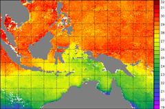
The connection might not be immediately obvious, but the NOAA satellites that orbit around the earth are a crucial tool in monitoring the environmental conditions that cause coral bleaching. How can a satellite that is 850km (530 miles) above the ocean help the coral colonies that grow below the surface? On board some of these satellites is a critical sensor called the Advanced Very High Resolution Radiometer, or AVHRR. This sensor measures the radiation that comes from the surface of the earth, including the ocean, allowing us to monitor the sea surface temperature (SST). Because the satellites orbit around the earth, NOAA measures SST around the entire globe every day. Please read on for more information about remote sensing, NOAA's satellite systems, and how these satellites measure the temperature of the ocean surface.
|
|
||||||||||||||||
|
|
||||||||||||||||||
|
IMPORTANT USER ALERT (2 July 2024): This past weekend, a storage server at NOAA's Center for Satellite Applications and Research, which delivers the NOAA Coral Reef Watch data, suffered a hardware failure. The issue is being addressed, and we hope to have the NOAA Coral Reef Watch data back up and running as soon as possible. (1) The most recent data will be made available first; historical data may take time to be restored. (2) If you need specific data that are not yet available, please contact us at coralreefwatch@noaa.gov. (3) If you use code to pull data, please revise your code to use “…/socd/…” in lieu of “…/sod/…” in all relevant web addresses for all future needs. We apologize for any inconvenience this may cause. |