


|
|
Remote sensing uses sensors that measure parts of the electromagnetic spectrum. This "spectrum" is a way of talking about natural energy: from x-rays and ultra-violet light (UV), through visible light, to infrared (IR) and microwaves-- see the figure below. At the left are high-energy waves like gamma rays, which can pass right through most physical matter. In the center is a narrow band of energy that our eyes are tuned to detect -- visible light, from higher-energy blue light to the lower-energy red. The next section of this spectrum is called infrared. This is energy that we feel as heat, like the heat that comes off the hot burner on your stove. All the way at the lower energy end (right) are radio waves, which have long wavelengths. Many of these forms of energy are used in remote sensing. All that is required to measure their energy remotely is a detector. 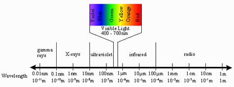
|
|
|||||||||||
|
|
|||||||||||||
|
IMPORTANT USER ALERT (2 July 2024): This past weekend, a storage server at NOAA's Center for Satellite Applications and Research, which delivers the NOAA Coral Reef Watch data, suffered a hardware failure. The issue is being addressed, and we hope to have the NOAA Coral Reef Watch data back up and running as soon as possible. (1) The most recent data will be made available first; historical data may take time to be restored. (2) If you need specific data that are not yet available, please contact us at coralreefwatch@noaa.gov. (3) If you use code to pull data, please revise your code to use “…/socd/…” in lieu of “…/sod/…” in all relevant web addresses for all future needs. We apologize for any inconvenience this may cause. |

