|
|
|
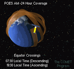
This diagram shows the orbital path of a NOAA polar-orbiting satellite.
Click the image for an animation of the POES orbit.
|

|
|
NOAA operates two different types of environmental satellites that carry remote sensing
instruments. Some of the satellites stay fixed above a certain spot on the Earth's equator:
these are called geostationary satellites (GOES).
The other kind orbits around the earth, passing close to the north and south poles on each
orbit many times a day: these are called polar-orbiting
satellites (POES).
Geostationary satellites stay in the same position relative to Earth, so they can take
frequent measurements of the same area throughout the day and night. However, each
satellite can only see a fraction of the Earth's surface.
Because coral reefs are located all around the world, Coral Reef Watch decided to use NOAA's
polar-orbiting satellites to develop its heritage suite of 50km satellite coral bleaching monitoring
products (discussed in subsequent tutorial chapters).
Although polar-orbiting satellites can only measure a given area once or twice
a day, they have the advantage of taking measurements around the entire planet.
(top)


