


• Click here to access protptype manager's portal for Puerto Rico.
Ocean Color Data Access for Puerto Rico and Hawaii (NetCDF):
• Click here to access NetCDF data files via FTP.
• Data files are science quality, ~750m resolution, and updated daily with a delay of 15 days.
• Click here for preliminary time series results for Puerto Rico.
• Click here for preliminary time series results for West Maui.
• Click here for a poster presented at the 2015 NOAA Satellite Conference.
• Click here for a poster presented at the 2016 Ocean Sciences Meeting in New Orleans.
NOAA Coral Reef Watch and NOAA/NESDIS' Ocean Color Team are working closely with partners in the U.S. Coral Reef Task Force (USCRTF) Watershed Working Group (WWG) to develop pilot satellite ocean color products using data from the Visible Infrared Imaging Radiometer Suite (VIIRS) aboard the Suomi National Polar-orbiting Partnership (S-NPP) satellite operated by the NOAA Joint Polar Satellite System (JPSS).
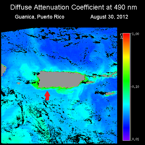
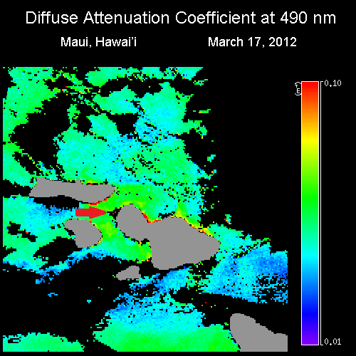
The pilot satellite ocean color products are designed to help coral reef ecosystem managers monitor variable water turbidity (diffuse attenuation coefficient at 490 nm, Kd(490)). Land-Based Sources of Pollution (LBSP), identifiable by a significant increase in water turbidity, especially following large precipitation events, is one of the major threats to coral reef health typically caused by coastal and upstream land development. Since chlorophyll a plays a role, as well, this parameter is also being addressed, but not shown here. Additional VIIRS ocean color measurements (e.g. Colored Dissolved Organic Matter (CDOM) and Total Suspended Solids (TSS)) will be included as they are developed and verified by the team.
Two high priority coral reef sites identified by the USCRTF WWG have been selected for development of the pilot ocean color products. These include, from left to right above: Guánica Bay, Puerto Rico and West Maui, Ka'anapali, Hawai'i. (Note that in the VIIRS Kd(490) images above, the exact location of each focal site is pinpointed by a red arrow.) The spatial resolution of the data used for deriving these images is 750 meters.
The pilot satellite ocean color products are being developed by NOAA Coral Reef Watch and NOAA/NESDIS' Ocean Color Team with support from NOAA's Ocean Remote Sensing program.

