|
|
|
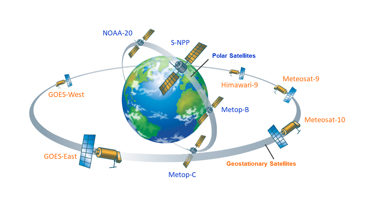
This diagram shows the 9 satellites (5 geostationary [orange] and 4 polar-orbiting [blue], updated July 18, 2023)
that contribute data to the daily global 5km satellite coral bleaching monitoring products. Click the image
to view a larger version.
|

|
|
NOAA and its partners operate two different types of environmental satellites that carry
remote sensing instruments (or sensors). Some of the satellites stay fixed at about
35,786 kilometers (or 22,236 miles) above a certain spot on the Earth's equator:
these are called geostationary satellites. Because geostationary satellites stay in the same
position relative to Earth, they can take frequent measurements of the same area throughout
the day and night. However, each geostationary satellite can only see a fraction of the
Earth's surface. For that reason, we also use data from another kind of satellite that is
located in Earth's lower orbit, at an altitude of less than 1,000 km (or 621 miles) above
the Earth's surface. Called a polar-orbiting satellite, this type of environmental satellite
orbits around the earth, passing close to the north and south poles on each orbit many times a day.
Although polar-orbiting satellites can only measure a given area once or twice a day, they have
the advantage of taking measurements around the entire planet.
CRW uses data from 9 environmental satellites (5 geostationary and 4 polar-orbiting [as of July 18, 2023])
operated by NOAA and its partners to build the daily global 5km satellite coral
bleaching monitoring products (discussed in subsequent tutorial chapters).
These 9 satellites, which are pictured in a schematic above, include:
NOAA's Geostationary Operational Environmental Satellite (GOES)-East
and GOES-West;
the European Organisation for the Exploitation of Meteorological Satellites' (EUMETSAT)
Meteosat Second Generation (MSG) satellites, Meteosat-9 and
Meteosat-10 ; the Japan Meteorological Agency's
Himawari-9;
the NOAA-20
Polar Operational Environmental Satellites (POES);
EUMETSAT's Metop-B and Metop-C;
and NOAA/NASA's Suomi National Polar-Orbiting Partnership (S-NPP).
; the Japan Meteorological Agency's
Himawari-9;
the NOAA-20
Polar Operational Environmental Satellites (POES);
EUMETSAT's Metop-B and Metop-C;
and NOAA/NASA's Suomi National Polar-Orbiting Partnership (S-NPP).
(top)


