Remote sensing
uses sensors that measure parts of the
electromagnetic spectrum .
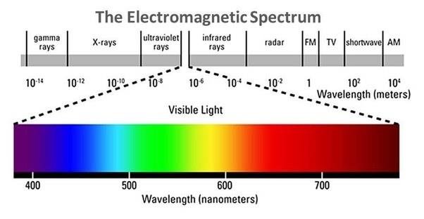
This "spectrum" is a way of talking about natural energy: from x-rays and ultra-violet light (UV),
through visible light, to infrared (IR) and microwaves-- see the figure below.
At the left are high-energy waves like gamma rays, which can pass right through most physical matter.
In the center is a narrow band of energy that our eyes are tuned to detect -- visible light,
from higher-energy blue light to the lower-energy red. The next section of this spectrum
is called infrared. This is energy that we feel as heat, like the heat that comes off the hot burner
on your stove. All the way at the lower energy end (right) are radio waves, which have
long wavelengths. Many of these forms of energy are used in remote sensing.
All that is required to measure their energy remotely is a detector.
.
This "spectrum" is a way of talking about natural energy: from x-rays and ultra-violet light (UV),
through visible light, to infrared (IR) and microwaves-- see the figure below.
At the left are high-energy waves like gamma rays, which can pass right through most physical matter.
In the center is a narrow band of energy that our eyes are tuned to detect -- visible light,
from higher-energy blue light to the lower-energy red. The next section of this spectrum
is called infrared. This is energy that we feel as heat, like the heat that comes off the hot burner
on your stove. All the way at the lower energy end (right) are radio waves, which have
long wavelengths. Many of these forms of energy are used in remote sensing.
All that is required to measure their energy remotely is a detector.
(top)